 |
Ei, hola! Sabies que Vikidia l'escriu gent normal com tu? Crea't un compte i uneix-te a la comunitat! |
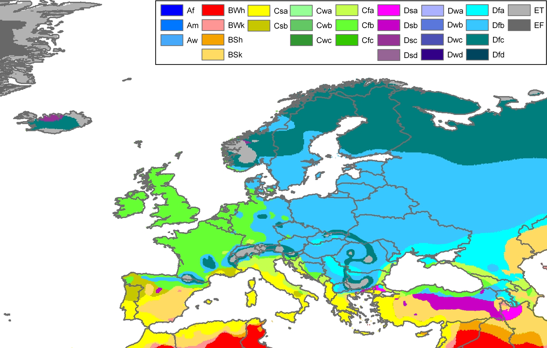
Fitxer:Europe Köppen Map.png
Salta a la navegació
Salta a la cerca


Mida d'aquesta previsualització: 800 × 509 píxels. Altres resolucions: 320 × 204 píxels | 640 × 407 píxels | 1.024 × 652 píxels | 1.280 × 815 píxels | 1.885 × 1.200 píxels.
Fitxer original (1.885 × 1.200 píxels, mida del fitxer: 831 Ko, tipus MIME: image/png)
| Peel, M. C. and Finlayson, B. L. and McMahon, T. A. (2007). "Updated world map of the Köppen-Geiger climate classification". Hydrol. Earth Syst. Sci. 11: 1633-1644. ISSN 1027-5606. |
Legend
Resum
| Descripció | Climate map of Europe (from the "Updated world map of the Köppen-Geiger climate classification"). |
| Data | |
| Font | Hydrology and Earth System Sciences: "Updated world map of the Köppen-Geiger climate classification" (Supplement) - Original file was a JPG-file, this file is has been converted to a PNG-file, without extra modifications, by me (Jeroen). |
| Autor |
Peel, M. C., Finlayson, B. L., and McMahon, T. A. (University of Melbourne) |
| Permís (Com reutilitzar aquest fitxer) |
|
| Altres versions | Derivative works of this file: Köppen Map Europe 01.png |
Related maps
User Jeroenvrp made for these continents and areas a cropped and resized version:
- Africa Köppen Map.png
- Asia Köppen Map.png
- Australia-Oceania Köppen Map.png
- Europe Köppen Map.png
- North America Köppen Map.png
- Russia Köppen Map.png
- South America Köppen Map.png
- West Asia Köppen Map.png.
User LordToran made from the same data these maps:
- Klimagürtel-der-erde-eisklima.png
- Klimagürtel-der-erde-gemäßigte-zone.png
- Klimagürtel-der-erde-polargebiete.png
- Klimagürtel-der-erde-subtropen.png
- Klimagürtel-der-erde-tropen.png
- Klimagürtel-der-erde-tundra.png
- Klimagürtel-der-erde-warmgemäßigte-zone.png
- Klimagürtel-der-erde.png
- Klimagürtel-der-erde.svg
- Klimate-humidität.png
- Köppen-geiger-hessd-2007.svg
- Köppen-vereinfacht.svg
- Trockenklimate.png
Llicència
Aquest fitxer està subjecte a la llicència de Creative Commons Reconeixement i Compartir Igual 3.0 No adaptada.
- Sou lliure de:
- compartir – copiar, distribuir i comunicar públicament l'obra
- adaptar – fer-ne obres derivades
- Amb les condicions següents:
- reconeixement – Heu de donar la informació adequada sobre l'autor, proporcionar un enllaç a la llicència i indicar si s'han realitzat canvis. Podeu fer-ho amb qualsevol mitjà raonable, però de cap manera no suggereixi que l'autor us dóna suport o aprova l'ús que en feu.
- compartir igual – Si modifiqueu, transformeu, o generareu amb el material, haureu de distribuir les vostres contribucions sota una llicència similar o una de compatible com l'original
Historial del fitxer
Cliqueu una data/hora per veure el fitxer tal com era aleshores.
| Data/hora | Miniatura | Dimensions | Usuari/a | Comentari | |
|---|---|---|---|---|---|
| actual | 00:30, 23 nov 2017 | | 1.885 × 1.200 (831 Ko) | wikimediacommons>Mélomène | Cantabrian Asturian, Pyrenean, Alps, Carpathian Mts formed ranges. |
Ús del fitxer
La pàgina següent utilitza aquest fitxer: