 |
Ei, hola! Sabies que Vikidia l'escriu gent normal com tu? Crea't un compte i uneix-te a la comunitat! |
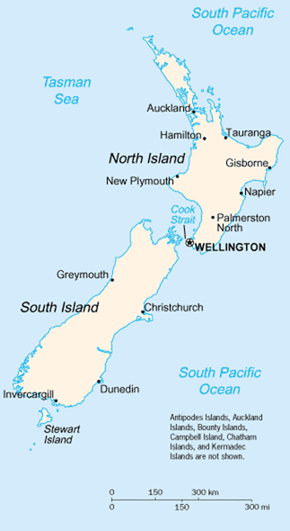
Fitxer:New Zealand map.PNG
New_Zealand_map.PNG (323 × 590 píxels, mida del fitxer: 89 Ko, tipus MIME: image/png)
A map of New Zealand showing the major cities and towns. Not shown are the Antipodes Islands, Auckland Islands, Bounty Islands, Campbell Island, The Snares, and the Kermadec Islands.
https://www.cia.gov/library/publications/the-world-factbook/geos/nz.html archive copy at the Wayback Machine
It should be noted that the scale on this map is not accurate. Measuring distances on the map then using the scale to determine those distances on the ground would lead to considerable exaggeration of those distances. This issue has been raised with the CIA, who compile these World Fact Book maps.
- Update - the latest version updated by Grutness is much better. Please see the Talk page for more.
This image is in the public domain because it contains materials that originally came from the United States Central Intelligence Agency's World Factbook.
|
 |
Historial del fitxer
Cliqueu una data/hora per veure el fitxer tal com era aleshores.
| Data/hora | Miniatura | Dimensions | Usuari/a | Comentari | |
|---|---|---|---|---|---|
| actual | 03:14, 30 jul 2005 | | 323 × 590 (89 Ko) | wikimediacommons>Grutness | scale corrected |
Ús del fitxer
La pàgina següent utilitza aquest fitxer: